My Travel and History Blog, Focussing mostly on Roman and Mediaeval Times
27 Jun 2011
'Twas King Arthurs Table Once - The Amphitheatre in Caerleon
Since gladiatorial fights, play performances, and the occasional public execution were so popular with the Romans, it's not that difficult to find the remains of amphitheatres. After the earth and timber one of Birten that may date as far back as Augustean times, we'll visit another one attached to a legionary fort, the stone and timber amphitheatre of Caerleon, dating to AD 90. In a lose series of blogposts, we'll move on to the grand 2nd and 3rd century stone amphitheatres of Trier and Chester, and finally visit the partly reconstructed one of Xanten, as well as the remains of the stage theatre in Mainz.

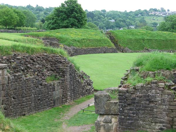
Roman amphitheatre in Caerleon
The amphitheatre of Caerleon is one of the prettiest today because the arena and the remains of the earthen support walls are overgrown with grass and make for a nice green oasis even on an overcast and dreary day.
To explain the title of this post:
Caerleon, the 'City of the Legions', has been connected with King Arthur since Nennius, author of the Historia Brittonum (~ 820, though the date is not undisputed) mentioned the place as localisation of one of the tvelwe battles the dux bellorum Arthur fought against the Saxon invaders (the most famous one is Mount Badon).

Remains of the southern entrance (seen from the arena)
Geoffrey of Monmouth, who was born not far from Caerleon, gives us a lively description of the City of the Legions in his Historia Regum Brittaniae (1136). After he has not only defeated the Saxons, but conquered Scotland, Orkney, Ireland and even Norway, King Arthur holds court at Caerleon to receive hommage of the princes and warlords. Monmouth describes the situation of the city, the river Usk and the meadows and groves surrounding it. At that time more Roman remains had been visible than today, as a visit by Gerald of Wales in 1188 proves. He doesn't make a connection to Arthur, but he mentions a tower, the baths, and the many subterranean passages and hypocausts.
The French verse adaption of Monmouth's Historia, de Wace's Brut (1155), introduces the Round Table. The table had been connected with the remains of the amphitheatre when some of the French who came in support of Owain Glyndŵr, visited the site, and an Elisabethean poem makes the same connection (Thomas Churchyard, The Worthines of Wales, 1587), albeit at that time a good deal of the stones had, erm .... migrated to the nearby houses.

Northern main entrance (with remains of the original pavement)
Caerleon, to the Romans knows as Isca Silurnum, was founded by S. Julius Frontinus, one of Vespasian's generals, in train of his conquest of the Silures AD 74 or 75. Isca was a legionary fort garrisoned by the Legio II Augusta - albeit not always in full strength - until about AD 290 when the fort was partly dismanted.
The fort lies in the territory of the Silures (let's show those pesky Welsh what a badass Roman army looks like), on a gently elevated plateau close to the river Usk, so that the garrison could by supplied by water - we know from my post about the Roman transport on the Rhine how important that was.
As usual, the fort attracted a cannabae legionis. The amphitheatre was situated in the settlement, near the public baths for the civilians.

Inside view
The amphitheatre dates to about AD 90. The legionaries had to wait much longer for that than for their baths; those were built the same time as the fort itself. The construction is interesting: a stone foundation of 4 metres height, filled with earth - the outer wall was 2 metres thick and buttressed to resist the pressure of the earth; the buttresses were repaired and reinforced several times. The outer layer of the walls was finished with smooth plaster decorated with red lines, imitating regular stones.
Above this was an open-framed timber grandstand with the wooden seating. It is assumed that it originally had been intended as temporary, but the amphitheatre never was completely rebuilt in stone, for whatever reason. It could hold 6000 spectators, that is, the entire legion plus guests (and the legion was rarely in Caerleon in its full strength, detachments would have been sent elsewhere).
North gate, from a different angle
The arena itself, somewhat below the outside ground level, is an oval of 56 x 41.5 metres, about the same size as Birten, though the latter looks much smaller today because of the trees and the partly collapsed earth walls. There were eight entrances; the ones on the long axis (north and south gates) were larger portae pompae through which processions and parades could march. They were vaulted on both ends, but the ceiling in the middle was left open (makes you wonder if the governor, emperor or whoever commissioned the building got short of money halfway through). Those entrances did not give access to the seating.
The entrances were paved and the arena covered with fine sand; grass would have been way too slippery, esp. in wet Wales. There also is a drain running all the way from the north to the south gate and further down into the Usk river. The drain still works today.

Western entrance with 'gladiator cell'
The spectators would use the six remaining entrances. The entrances on the short axis had cells above the gate, between the staircases leading up to the seatings on both sides of the entrance. Those had access to both the outer staircase and the arena (by another small staircase) and held the gladiators or animals. The two gates also had a terrace and a private room above the gladiator cells at the inner stone wall level. Those were occupied by special guests.
The gate vaults were made of stone, but most of the inner construction was made of bricks. The brick wall of the 'gladator cell / animal pit' in the western entrance can still be seen. For some reason, the entrance was filled up to outer ground level during the renovations under Caracalla (AD 212), and access to the left staircase was blocked, which resulted in the gladiator cell opening only towards the arena. Today the level is back at the original one.

Eastern entrance
(The brick niche is visible above the remains of the arena gate)
The eastern gate was altered even more. During a renovation taking place around AD 125, one of the staircases was blocked and the gladiator cell was partly walled in and furnished with a counter for a ticket collector. I have no idea where gladiators and animals were kept at that time during the hours before they entered the arena.
Later the ground level was filled in, and a brick niche was inserted in the gladiator room which is assumed to have held a shrine dedicated to Nemesis, the goddess of fate and vengeance who was very popular with the gladiators (the arena in Chester has a Nemesis shrine as well). A leaden curse tablet asking Nemesis to do ill to the thief of a cloak and a pair of boots has been found on the site.
The 'chamber for honoured guests' must have been situated above the shrine.

Outside buttresses
The town of Caerleon had for a long time occupied but part of the former fort, but in the early 20th century, it threatened to extend further onto Roman remains. Fortunately, interest in the old remains grew, and a local excavation commitee was set up, led by the director of the National Museum of Wales, Sir Mortimer Wheeler. Wheeler started media campaigns to fund an excavation of the amphitheatre and buy Prysg Field where he assumed parts of the Roman fort could be found and which was going on the market as building land (it now shows the remains of some fort barracks). Excavations at the amphitheatre took place in 1909 and again 1926-27.
Today, the amphitheatre in Caerleon is the best preseved in Great Britain.
Sources:
Volker Mertens, Artus. In: V. Mertens and U. Müller (ed). Epische Stoffe des Mittelalters. Stuttgart , 1984; pp. 290 - 340
The Caerleon Guidebook by CADW
¶ June 27, 2011 11 comments
Since gladiatorial fights, play performances, and the occasional public execution were so popular with the Romans, it's not that difficult to find the remains of amphitheatres. After the earth and timber one of Birten that may date as far back as Augustean times, we'll visit another one attached to a legionary fort, the stone and timber amphitheatre of Caerleon, dating to AD 90. In a lose series of blogposts, we'll move on to the grand 2nd and 3rd century stone amphitheatres of Trier and Chester, and finally visit the partly reconstructed one of Xanten, as well as the remains of the stage theatre in Mainz.

The amphitheatre of Caerleon is one of the prettiest today because the arena and the remains of the earthen support walls are overgrown with grass and make for a nice green oasis even on an overcast and dreary day.
To explain the title of this post:
Caerleon, the 'City of the Legions', has been connected with King Arthur since Nennius, author of the Historia Brittonum (~ 820, though the date is not undisputed) mentioned the place as localisation of one of the tvelwe battles the dux bellorum Arthur fought against the Saxon invaders (the most famous one is Mount Badon).
Geoffrey of Monmouth, who was born not far from Caerleon, gives us a lively description of the City of the Legions in his Historia Regum Brittaniae (1136). After he has not only defeated the Saxons, but conquered Scotland, Orkney, Ireland and even Norway, King Arthur holds court at Caerleon to receive hommage of the princes and warlords. Monmouth describes the situation of the city, the river Usk and the meadows and groves surrounding it. At that time more Roman remains had been visible than today, as a visit by Gerald of Wales in 1188 proves. He doesn't make a connection to Arthur, but he mentions a tower, the baths, and the many subterranean passages and hypocausts.
The French verse adaption of Monmouth's Historia, de Wace's Brut (1155), introduces the Round Table. The table had been connected with the remains of the amphitheatre when some of the French who came in support of Owain Glyndŵr, visited the site, and an Elisabethean poem makes the same connection (Thomas Churchyard, The Worthines of Wales, 1587), albeit at that time a good deal of the stones had, erm .... migrated to the nearby houses.
Caerleon, to the Romans knows as Isca Silurnum, was founded by S. Julius Frontinus, one of Vespasian's generals, in train of his conquest of the Silures AD 74 or 75. Isca was a legionary fort garrisoned by the Legio II Augusta - albeit not always in full strength - until about AD 290 when the fort was partly dismanted.
The fort lies in the territory of the Silures (let's show those pesky Welsh what a badass Roman army looks like), on a gently elevated plateau close to the river Usk, so that the garrison could by supplied by water - we know from my post about the Roman transport on the Rhine how important that was.
As usual, the fort attracted a cannabae legionis. The amphitheatre was situated in the settlement, near the public baths for the civilians.
The amphitheatre dates to about AD 90. The legionaries had to wait much longer for that than for their baths; those were built the same time as the fort itself. The construction is interesting: a stone foundation of 4 metres height, filled with earth - the outer wall was 2 metres thick and buttressed to resist the pressure of the earth; the buttresses were repaired and reinforced several times. The outer layer of the walls was finished with smooth plaster decorated with red lines, imitating regular stones.
Above this was an open-framed timber grandstand with the wooden seating. It is assumed that it originally had been intended as temporary, but the amphitheatre never was completely rebuilt in stone, for whatever reason. It could hold 6000 spectators, that is, the entire legion plus guests (and the legion was rarely in Caerleon in its full strength, detachments would have been sent elsewhere).
The arena itself, somewhat below the outside ground level, is an oval of 56 x 41.5 metres, about the same size as Birten, though the latter looks much smaller today because of the trees and the partly collapsed earth walls. There were eight entrances; the ones on the long axis (north and south gates) were larger portae pompae through which processions and parades could march. They were vaulted on both ends, but the ceiling in the middle was left open (makes you wonder if the governor, emperor or whoever commissioned the building got short of money halfway through). Those entrances did not give access to the seating.
The entrances were paved and the arena covered with fine sand; grass would have been way too slippery, esp. in wet Wales. There also is a drain running all the way from the north to the south gate and further down into the Usk river. The drain still works today.
The spectators would use the six remaining entrances. The entrances on the short axis had cells above the gate, between the staircases leading up to the seatings on both sides of the entrance. Those had access to both the outer staircase and the arena (by another small staircase) and held the gladiators or animals. The two gates also had a terrace and a private room above the gladiator cells at the inner stone wall level. Those were occupied by special guests.
The gate vaults were made of stone, but most of the inner construction was made of bricks. The brick wall of the 'gladator cell / animal pit' in the western entrance can still be seen. For some reason, the entrance was filled up to outer ground level during the renovations under Caracalla (AD 212), and access to the left staircase was blocked, which resulted in the gladiator cell opening only towards the arena. Today the level is back at the original one.
(The brick niche is visible above the remains of the arena gate)
The eastern gate was altered even more. During a renovation taking place around AD 125, one of the staircases was blocked and the gladiator cell was partly walled in and furnished with a counter for a ticket collector. I have no idea where gladiators and animals were kept at that time during the hours before they entered the arena.
Later the ground level was filled in, and a brick niche was inserted in the gladiator room which is assumed to have held a shrine dedicated to Nemesis, the goddess of fate and vengeance who was very popular with the gladiators (the arena in Chester has a Nemesis shrine as well). A leaden curse tablet asking Nemesis to do ill to the thief of a cloak and a pair of boots has been found on the site.
The 'chamber for honoured guests' must have been situated above the shrine.
The town of Caerleon had for a long time occupied but part of the former fort, but in the early 20th century, it threatened to extend further onto Roman remains. Fortunately, interest in the old remains grew, and a local excavation commitee was set up, led by the director of the National Museum of Wales, Sir Mortimer Wheeler. Wheeler started media campaigns to fund an excavation of the amphitheatre and buy Prysg Field where he assumed parts of the Roman fort could be found and which was going on the market as building land (it now shows the remains of some fort barracks). Excavations at the amphitheatre took place in 1909 and again 1926-27.
Today, the amphitheatre in Caerleon is the best preseved in Great Britain.
Sources:
Volker Mertens, Artus. In: V. Mertens and U. Müller (ed). Epische Stoffe des Mittelalters. Stuttgart , 1984; pp. 290 - 340
The Caerleon Guidebook by CADW
¶ June 27, 2011 11 comments
18 Jun 2011
Baiting Bears and Torturing Martyrs - The Amphitheatre in Birten / Xanten
The first legionary fort on the Fürstenberg hill near Xanten, known as Castra Vetera I, goes back to at least 12 BC when Drusus started his campaigns into Germania. Digs during the first third of the 20th century have shown a number of at least five forts that were built partly over each other, so that most traces of the older ones have been obscured. Moreover, the first forts had been constructed in half-timbered style with earth or timber/earth walls. Aerial surveys in the last years have rendered more traces of those. But the best-researched is the fort from Nero's time that later got destroyed during the Batavian rebellion in AD 70.

Amphitheatre Birten, entrance
After the war, the fort was rebuilt nearby as Vetera II, in a space now under the waters of the shifting Rhine. The various version of Vetera I lie under agricultural fields these days.
Vetera I had been a fort for two legions since the time of Germanicus (AD 14) if not earlier. As such it attracted a cannabae legionis, but those civilian settlements have left even fewer traces and were never really researched, though aerial surveys show a regular Roman street pattern outside the Neronic fort, so one can conclude that the the place became a Roman-planned settlement at some point. There also seems to have been a 100 metres 'safety distance' between fort and settlement.

View from above the spectator rows
The cannabae were destroyed during the Batavian rebellion as well, and when the fort was moved, a new settlement - later to become Colonia Ulpia Traiana - was created in the place that now hosts the Archaeological Park. The only remains of the old cannabae today is an amphitheatre in the village of Birten.
When we think of amphitheatres today, we have an image of the often stunning stone buildings that are spread all over the Roman Empire. But they started out much smaller: For a long time, the arenas for gladitorial combat were timber structures that would be dismantled again after the performances. But some of those collapsed and killed people, so during the time of Caesar, the specatator rows more and more often were erected on firm ground, using natural slopes or earth and timber walls (like Augustean fortifications), and eventually developed into stone buildings which also allowed for much larger constructions.

View from the arena to the entrance
Leginonaries got grumpy when they couldn't watcht the occasional gladiator fight or bear baiting (bear bones have been found in Birten), so it's no surprise that a large fort like Vetera would eventually get its own amphitheatre. It's an oval earthern structure of 98 x 84 metres; the arena proper measures 55.5 x 42.5 metres. The walls had originally been 8 metres high, and the theatre could hold 10.000 spectators. The seats once had been of wood, but now there are modern chairs on one side of the arena because the theatre is used for concerts and play performances today. It's a pretty place, surrounded by trees and deceivingly peaceful, considering its violent past.
Another view from above
A reason the amphitheatre survived is its connection with the martyr St.Victor who is said to have been executed in the arena. Victor was a member of the Theban legion of legends and Christian historiography. It is said to have been a 3rd century legion entirely converting to Christian faith, which got decimated several times on the march through the Alpes, France and along the Rhine. Victor and some 300 of his men were the last ones to end that way - well, Xanten was the last place to kill them before they would have reached the sea. The legion became the collection bin for pretty much every saint along the way, most prominently among them St.Maurice (aka St.Mark).

The reconstructed amphitheatre in the APX Xanten
I don't know why the connection was made between Victor and Birten in the Middle Ages; if he was indeed member of a Roman legion and executed for his faith somewhere near Xanten, the stone amphitheatre in the Colonia Ulpia Traiana would have been a more likely place. It was still in use at the time of Constantin the Great († AD 337), while Victor's martydom took place somewhat earlier. One explanatiion could be the fact that the veneration of St.Victor can be traced clearly only to the 8th century, and by then a transfer of the legend to the amphitheatre in Birten would be possible.
Sources:
Norbert Hanel, Die Militärlager von Vetera I und ihre Lagersiedlingen, in:
M. Müller, H.-J. Schalling, N. Zieling (ed), Colonia Ulpia Traiana - Xanten und sein Umland in römischer Zeit. Mainz 2009, pp. 93-107
¶ June 18, 2011 11 comments
The first legionary fort on the Fürstenberg hill near Xanten, known as Castra Vetera I, goes back to at least 12 BC when Drusus started his campaigns into Germania. Digs during the first third of the 20th century have shown a number of at least five forts that were built partly over each other, so that most traces of the older ones have been obscured. Moreover, the first forts had been constructed in half-timbered style with earth or timber/earth walls. Aerial surveys in the last years have rendered more traces of those. But the best-researched is the fort from Nero's time that later got destroyed during the Batavian rebellion in AD 70.
After the war, the fort was rebuilt nearby as Vetera II, in a space now under the waters of the shifting Rhine. The various version of Vetera I lie under agricultural fields these days.
Vetera I had been a fort for two legions since the time of Germanicus (AD 14) if not earlier. As such it attracted a cannabae legionis, but those civilian settlements have left even fewer traces and were never really researched, though aerial surveys show a regular Roman street pattern outside the Neronic fort, so one can conclude that the the place became a Roman-planned settlement at some point. There also seems to have been a 100 metres 'safety distance' between fort and settlement.
The cannabae were destroyed during the Batavian rebellion as well, and when the fort was moved, a new settlement - later to become Colonia Ulpia Traiana - was created in the place that now hosts the Archaeological Park. The only remains of the old cannabae today is an amphitheatre in the village of Birten.
When we think of amphitheatres today, we have an image of the often stunning stone buildings that are spread all over the Roman Empire. But they started out much smaller: For a long time, the arenas for gladitorial combat were timber structures that would be dismantled again after the performances. But some of those collapsed and killed people, so during the time of Caesar, the specatator rows more and more often were erected on firm ground, using natural slopes or earth and timber walls (like Augustean fortifications), and eventually developed into stone buildings which also allowed for much larger constructions.
Leginonaries got grumpy when they couldn't watcht the occasional gladiator fight or bear baiting (bear bones have been found in Birten), so it's no surprise that a large fort like Vetera would eventually get its own amphitheatre. It's an oval earthern structure of 98 x 84 metres; the arena proper measures 55.5 x 42.5 metres. The walls had originally been 8 metres high, and the theatre could hold 10.000 spectators. The seats once had been of wood, but now there are modern chairs on one side of the arena because the theatre is used for concerts and play performances today. It's a pretty place, surrounded by trees and deceivingly peaceful, considering its violent past.
A reason the amphitheatre survived is its connection with the martyr St.Victor who is said to have been executed in the arena. Victor was a member of the Theban legion of legends and Christian historiography. It is said to have been a 3rd century legion entirely converting to Christian faith, which got decimated several times on the march through the Alpes, France and along the Rhine. Victor and some 300 of his men were the last ones to end that way - well, Xanten was the last place to kill them before they would have reached the sea. The legion became the collection bin for pretty much every saint along the way, most prominently among them St.Maurice (aka St.Mark).
I don't know why the connection was made between Victor and Birten in the Middle Ages; if he was indeed member of a Roman legion and executed for his faith somewhere near Xanten, the stone amphitheatre in the Colonia Ulpia Traiana would have been a more likely place. It was still in use at the time of Constantin the Great († AD 337), while Victor's martydom took place somewhat earlier. One explanatiion could be the fact that the veneration of St.Victor can be traced clearly only to the 8th century, and by then a transfer of the legend to the amphitheatre in Birten would be possible.
Sources:
Norbert Hanel, Die Militärlager von Vetera I und ihre Lagersiedlingen, in:
M. Müller, H.-J. Schalling, N. Zieling (ed), Colonia Ulpia Traiana - Xanten und sein Umland in römischer Zeit. Mainz 2009, pp. 93-107
¶ June 18, 2011 11 comments
14 Jun 2011
Forward, Drifting North on Ice - The Fram Museum in Oslo
And now for something completely different that's not Roman or Mediaeval. After visiting the Viking Ship Museum and a stave church in Oslo, I had some time left and decided to take a jump to the late 19th / early 20th century and look at the Fram; Fridtjof Nansen's ship for polar expeditions. The ship is located inside a hall today, so I couldn't take a shot of the complete vessel; you'll get her in bits and pieces.
That's what the Fram 1 looked like. Fram means 'Forward', btw, thus the title of the post.

Model of the Fram-1
In the late 19th century, the poles were some of the few white spots left on the world map. One of the Arctic explorers trying to tackle those white spots was the Norwegian Fridtjof Nansen. He liked cold, ice and snow, it seems, because he'd already done fun things like crossing Greenland on ski. Visiting the North Pole was another voyage no one had done before, and so he put it on his To Do List (which also included finishing his PhD in Zoology and participating in ski jumping competitions).
Nansen was convinced there must be a current floating from Asia to a point between Greenland and Svalbard which might corss the North Pole. Not many people believed him, so Nansen looked for a way to prove it. Sticking something into the ice near Siberia and watch it come out near Svalbard sounded like an idea. Nansen wanted to stick an entire ship into the ice, plus he could get a free ride to the pole that way. Now, the problem with ice is that it can crack a wooden ship like a nut. Nansen needed a special ship that would be pushed onto the ice instead of ending up as ship haggis between the ice blocks, and he needed money.

View from the bridge of the Fram to the quarterdeck
Nansen managed to convince the Norwegian National Assembly to grant him a fund, and he also found some private contributors (weren't that good times when people were willing to invest money in something that would not give them any profit but 'only' knowledge?). Nansen, Otto Sverdrup, another Arctic explorer, and Colin Archer, a ship architect whose parents had imigrated from Scotland, put their heads together and designed the Fram.
The ship should be small and light, but sturdy, yet offer enough comfort for a dozen men to live onboard for what looked like years. What they came up with was a three mast schooner of 39 metres length, a beam of 11 metres, a draught of 5 metres (which makes her unusually wide and shallow) and a displacement of 800 tons. The hull was designed in a way that it would be lifted onto the ice. Moreover, the Fram has almost no keel; rudder and propeller could be retracted into the ship. The outer layer is made of extremely durable greenheart wood. Besides the sails, the Fram has a triple expansion steam engine, and could make a speed of 7 knots (13 km/h). There was also a windmill to generate electricity for the lamps (that would come handy during the polar nights).

Fram (with Sverdrup's changes), the hull
The Fram set out on her first expedition on June 24, 1893. Fridtjof Nansen as leader of the scientific part and Otto Sverdrup as captain were among the thirteen brave souls to participate in the adventure. They left Oslo and went along the Norwegian coast all the way do Vardø at the Barent Sea (that's an extended Hurtigruten tour there, lol). They stopped in Bergen, Trondheim and Tromsø where our explorers were celebrated and banquetted even before they had explored anything. On July 21, they departed for the route to Novaya Semlya and some other Russian harbours where they took in dogs, and further to the North Siberian Islands. They reached the ice on September 22 and the long journey back to somewhere near Svalbard began.
A few days later, the rudder and propeller were taken in, the dogs moved to kennels on the ice, and the men made themselves comfortable.The ship rose and fell with the ice pressure but didn't suffer any damage. Polar night set in on October 25.
Boredom seems to have been one of the biggest problems (I think the men would have loved the idea of e-readers and Netflix; the piano on board only went so far, obviously). The drift was about 1 mile per day (1.6 km/h; which is still better than the speed in a London rush hour). Only once, in January 1895, the pressure of the ice became so dangerous that the men put the equipment out onto the ice and prepared for abandoning the ship, but the Fram held and was pushed out of the trap.

View from the bridge to the bow (the bowsprit is visible close to the wall)
During the summer 1894, Nansen realised that the Fram would drift quite a bit away from the pole. He had planned to reach the North Pole on an excursion if the ship wouldn't touch it, and now began preparations for a nice little walk on the ice. Sledges and Inuit style kayaks were built; Nansen started to learn the job of a musher and had the men train skiing. It soon turned out that a combination of the men skiing and the dogs dragging the sleds with proviant and equipment was the best way to proceed.
Nansen intended to reach the pole, then continue to the Franz Josef Land archipelago and further to Svalbard on the pack ice, using kayaks to cross open waters, and get a hike back home from there (he must have been quite an optimist; that island isn't exactly located on a main shipping route). He had no illusions about ever again finding his little ship drifting in a vast desert of ice without GPS.
Nansen and Hjalmar Johansen, a world championship athlete with a fondness for adventure and, as it turned out, a good hand with dogs, who had hired on the Fram as stoker, set off on March 14, 1895, with the ship at 84°4'N. They brought three dog sleds with equipment and food.

The diesel engine added by Amundsen in 1910
At first, the men made good progress, but eventually, the terrain became more difficult to traverse, with "a veritable chaos of ice blocks stretching as far as the horizon," as Nansen noted in his diary with half-frozen fingers. They also hit a southerly drift that carried them off, and began to run low on food if they wanted it to last for the retour pass to Franz Josef Land. On April 7, Nansen decided they would turn back. They had reached 86°14'N, the closest to the North Pole anyone had ever gotten by then.
The return journey to Franz Josef Land was a difficult and dangerous one. Since it was summer, the ice broke up and forced the men to cross open water and floes. Provisions ran even lower, and they had to kill most of the dogs. The men had to camp on a floe for a month in July, though by that time they could add seals and birds to the diet.
Soon thereafter they reached the end of the pack ice and sailed over to Franz Josef Land on a catamaran which they had created by lashing the two kayaks together, fixing the sleds on top, and setting up a makeshift sail.

The crankshaft
Futher progress to Svalbard was hindered by the approaching Arctic winter - the first ice began to form again - and on August 28, Nansen decided they would spend the winter on the archipelago. They built a pit house style hut of stone, moss and walrus skins. Food was less of an issue at the coast; there was plenty of polar bear, walrus and fish to stock up on. It would later turn out that the men had gained some weight despite their privations and exercise. Walrus blubber does that to you, obviously. Walrus oil also provided burning material for lamps.
Nansen and Johansen spent eight months there, being pretty bored (not even a piano around this time). On May 19, 1896, they set off along the coast in search of a spot to cross over to Svalbard. That trip surely was not boring. They were attacked by a walrus, Nansen once had to swim in barely liquid water to catch the eloping kayaks, and other fun. But they had some luck this time. Before they set out for Svalbard on that questionable catamaran, the men met with another expedition at Cape Flora in the south of the achipelago. The British explorer Frederick G. Jackson picked them up, gave them a bath and a haircut, and ride back on his supply ship, the Windward. Nansen and Johansen arrived in Vardø on August 13, 1896.

Fram, view to the stern
Meanwhile, the Fram, under command of Otto Sverdrup, continued to drift in the ice. Boredom was still an issue, so Sverdrup orderd all sorts of programs to keep people busy, from spring cleaning the ship to skiing practice. Research was also going on; the Fram had developed into a biological, oceanographic, and meteorological laboratory. They data the men collected would take years to evaluate and publish.
The ship reached open waters again pretty much at the spot near Svalbard which Nansen had predicted the same day Nansen arrived in Vardø: on August 13, 1896, and on August 20, the Fram arrived in the little harbour of Skjervøy in Norway. Six days later, Sverdrup and the crew of the Fram met with Nansen and Johansen in Tromsø where they were celebrated. The way back along the coast to Oslo (then still named Christiania) likened a triumphal parade with a lot more stops and banquets than three years ago. In Oslo the explorers were received by the king and invited to an extra big banquet (I bet the guys stayed away from any scale those weeks).

Foredeck with anchor chain
Nansen's successful expedition - the first into the polar zones from which all members returned safely - started a wave of interest in Arctic explorations. Otto Sverdrup was to lead the Fram north again to chart and explore the northern fjords of Greenland and the Canadian Arctic Islands. It would be the most scientific of the ship's journeys, taking place from June 1898 to September 1902. The material brought back was even more extensive than that gathered during the first expedition; it was published in 5 volumes between 1919 - 1930 (and that's not counting the 2000 glass containers with samples).
Sverdrup had altered the Fram a bit, raising the freeboard by 6 feet and adding a new deck that extended from the engine and could hold six more cabins - his team had 16 members instead of 13, and more space was welcome. This is the version we can see today.

Steering wheel on the quarterdeck
On Sverdrup's return, the Fram was laid up, but it was not the end of her voyages. Roald Amundsen would take her to the Antarctic on his South Pole expedition (1910-1912) but I'll leave that for another post, together with some photos of the interior of the Fram and the museum exhibits.
Sources:
'Fram: Norsk Polarhistorie'; a booklet avaliable at the museum
¶ June 14, 2011 9 comments
And now for something completely different that's not Roman or Mediaeval. After visiting the Viking Ship Museum and a stave church in Oslo, I had some time left and decided to take a jump to the late 19th / early 20th century and look at the Fram; Fridtjof Nansen's ship for polar expeditions. The ship is located inside a hall today, so I couldn't take a shot of the complete vessel; you'll get her in bits and pieces.
That's what the Fram 1 looked like. Fram means 'Forward', btw, thus the title of the post.
In the late 19th century, the poles were some of the few white spots left on the world map. One of the Arctic explorers trying to tackle those white spots was the Norwegian Fridtjof Nansen. He liked cold, ice and snow, it seems, because he'd already done fun things like crossing Greenland on ski. Visiting the North Pole was another voyage no one had done before, and so he put it on his To Do List (which also included finishing his PhD in Zoology and participating in ski jumping competitions).
Nansen was convinced there must be a current floating from Asia to a point between Greenland and Svalbard which might corss the North Pole. Not many people believed him, so Nansen looked for a way to prove it. Sticking something into the ice near Siberia and watch it come out near Svalbard sounded like an idea. Nansen wanted to stick an entire ship into the ice, plus he could get a free ride to the pole that way. Now, the problem with ice is that it can crack a wooden ship like a nut. Nansen needed a special ship that would be pushed onto the ice instead of ending up as ship haggis between the ice blocks, and he needed money.
Nansen managed to convince the Norwegian National Assembly to grant him a fund, and he also found some private contributors (weren't that good times when people were willing to invest money in something that would not give them any profit but 'only' knowledge?). Nansen, Otto Sverdrup, another Arctic explorer, and Colin Archer, a ship architect whose parents had imigrated from Scotland, put their heads together and designed the Fram.
The ship should be small and light, but sturdy, yet offer enough comfort for a dozen men to live onboard for what looked like years. What they came up with was a three mast schooner of 39 metres length, a beam of 11 metres, a draught of 5 metres (which makes her unusually wide and shallow) and a displacement of 800 tons. The hull was designed in a way that it would be lifted onto the ice. Moreover, the Fram has almost no keel; rudder and propeller could be retracted into the ship. The outer layer is made of extremely durable greenheart wood. Besides the sails, the Fram has a triple expansion steam engine, and could make a speed of 7 knots (13 km/h). There was also a windmill to generate electricity for the lamps (that would come handy during the polar nights).
The Fram set out on her first expedition on June 24, 1893. Fridtjof Nansen as leader of the scientific part and Otto Sverdrup as captain were among the thirteen brave souls to participate in the adventure. They left Oslo and went along the Norwegian coast all the way do Vardø at the Barent Sea (that's an extended Hurtigruten tour there, lol). They stopped in Bergen, Trondheim and Tromsø where our explorers were celebrated and banquetted even before they had explored anything. On July 21, they departed for the route to Novaya Semlya and some other Russian harbours where they took in dogs, and further to the North Siberian Islands. They reached the ice on September 22 and the long journey back to somewhere near Svalbard began.
A few days later, the rudder and propeller were taken in, the dogs moved to kennels on the ice, and the men made themselves comfortable.The ship rose and fell with the ice pressure but didn't suffer any damage. Polar night set in on October 25.
Boredom seems to have been one of the biggest problems (I think the men would have loved the idea of e-readers and Netflix; the piano on board only went so far, obviously). The drift was about 1 mile per day (1.6 km/h; which is still better than the speed in a London rush hour). Only once, in January 1895, the pressure of the ice became so dangerous that the men put the equipment out onto the ice and prepared for abandoning the ship, but the Fram held and was pushed out of the trap.
During the summer 1894, Nansen realised that the Fram would drift quite a bit away from the pole. He had planned to reach the North Pole on an excursion if the ship wouldn't touch it, and now began preparations for a nice little walk on the ice. Sledges and Inuit style kayaks were built; Nansen started to learn the job of a musher and had the men train skiing. It soon turned out that a combination of the men skiing and the dogs dragging the sleds with proviant and equipment was the best way to proceed.
Nansen intended to reach the pole, then continue to the Franz Josef Land archipelago and further to Svalbard on the pack ice, using kayaks to cross open waters, and get a hike back home from there (he must have been quite an optimist; that island isn't exactly located on a main shipping route). He had no illusions about ever again finding his little ship drifting in a vast desert of ice without GPS.
Nansen and Hjalmar Johansen, a world championship athlete with a fondness for adventure and, as it turned out, a good hand with dogs, who had hired on the Fram as stoker, set off on March 14, 1895, with the ship at 84°4'N. They brought three dog sleds with equipment and food.
At first, the men made good progress, but eventually, the terrain became more difficult to traverse, with "a veritable chaos of ice blocks stretching as far as the horizon," as Nansen noted in his diary with half-frozen fingers. They also hit a southerly drift that carried them off, and began to run low on food if they wanted it to last for the retour pass to Franz Josef Land. On April 7, Nansen decided they would turn back. They had reached 86°14'N, the closest to the North Pole anyone had ever gotten by then.
The return journey to Franz Josef Land was a difficult and dangerous one. Since it was summer, the ice broke up and forced the men to cross open water and floes. Provisions ran even lower, and they had to kill most of the dogs. The men had to camp on a floe for a month in July, though by that time they could add seals and birds to the diet.
Soon thereafter they reached the end of the pack ice and sailed over to Franz Josef Land on a catamaran which they had created by lashing the two kayaks together, fixing the sleds on top, and setting up a makeshift sail.
Futher progress to Svalbard was hindered by the approaching Arctic winter - the first ice began to form again - and on August 28, Nansen decided they would spend the winter on the archipelago. They built a pit house style hut of stone, moss and walrus skins. Food was less of an issue at the coast; there was plenty of polar bear, walrus and fish to stock up on. It would later turn out that the men had gained some weight despite their privations and exercise. Walrus blubber does that to you, obviously. Walrus oil also provided burning material for lamps.
Nansen and Johansen spent eight months there, being pretty bored (not even a piano around this time). On May 19, 1896, they set off along the coast in search of a spot to cross over to Svalbard. That trip surely was not boring. They were attacked by a walrus, Nansen once had to swim in barely liquid water to catch the eloping kayaks, and other fun. But they had some luck this time. Before they set out for Svalbard on that questionable catamaran, the men met with another expedition at Cape Flora in the south of the achipelago. The British explorer Frederick G. Jackson picked them up, gave them a bath and a haircut, and ride back on his supply ship, the Windward. Nansen and Johansen arrived in Vardø on August 13, 1896.
Meanwhile, the Fram, under command of Otto Sverdrup, continued to drift in the ice. Boredom was still an issue, so Sverdrup orderd all sorts of programs to keep people busy, from spring cleaning the ship to skiing practice. Research was also going on; the Fram had developed into a biological, oceanographic, and meteorological laboratory. They data the men collected would take years to evaluate and publish.
The ship reached open waters again pretty much at the spot near Svalbard which Nansen had predicted the same day Nansen arrived in Vardø: on August 13, 1896, and on August 20, the Fram arrived in the little harbour of Skjervøy in Norway. Six days later, Sverdrup and the crew of the Fram met with Nansen and Johansen in Tromsø where they were celebrated. The way back along the coast to Oslo (then still named Christiania) likened a triumphal parade with a lot more stops and banquets than three years ago. In Oslo the explorers were received by the king and invited to an extra big banquet (I bet the guys stayed away from any scale those weeks).
Nansen's successful expedition - the first into the polar zones from which all members returned safely - started a wave of interest in Arctic explorations. Otto Sverdrup was to lead the Fram north again to chart and explore the northern fjords of Greenland and the Canadian Arctic Islands. It would be the most scientific of the ship's journeys, taking place from June 1898 to September 1902. The material brought back was even more extensive than that gathered during the first expedition; it was published in 5 volumes between 1919 - 1930 (and that's not counting the 2000 glass containers with samples).
Sverdrup had altered the Fram a bit, raising the freeboard by 6 feet and adding a new deck that extended from the engine and could hold six more cabins - his team had 16 members instead of 13, and more space was welcome. This is the version we can see today.
On Sverdrup's return, the Fram was laid up, but it was not the end of her voyages. Roald Amundsen would take her to the Antarctic on his South Pole expedition (1910-1912) but I'll leave that for another post, together with some photos of the interior of the Fram and the museum exhibits.
Sources:
'Fram: Norsk Polarhistorie'; a booklet avaliable at the museum
¶ June 14, 2011 9 comments
5 Jun 2011
Castles of the Welsh Princes - Criccieth Castle 2: King Edward's Buildings
Edward's conquest of Wales should get its own post because he's to blame for some of those big castles I visited, but I'd need to find some reliable books or essays to draw upon. Well, here's a short version for starters.
Despite the Treaty of Montgomery, Llywelyn ap Gruffydd continued to face troubles with his Welsh neighbours (esp. the princes of Powys and Deheubarth) who didn't like being the vassals of another Welsh prince; the English Marcher lords who kept trying to nibble bits off Wales; and his brother Dafydd who, like any good Welsh brother, tried to kill Llywelyn and, when the plot failed, ran off to the king of England.

Criccieth Castle seen from the town
When Edward I ascended to the throne and summoned Llywelyn to renew his oath of fealty, Llywelyn replied that Edward should first address his grievances about Marcher lords and hiding brothers. From Edward's point, Llywelyn's refusal to swear fealty was, of course, treason. Moreover, Llywelyn was planning to marry Eleanor de Montfort, a daughter of that rebellious baron.
So Edward kidnapped Eleanor, took her into royal custody, and declared war on Llywelyn in 1276. Several of the Welsh rulers fell over each other to make peace with Edward (isn't that so Welsh?), and so the King of England could surround Llywelyn's lands and force him to surrender without too much trouble. The treaty of Aberconwy restored more or less the situation of the 1240ies: Llywelyn's possessions and feudal influence were reduced to the lands of his family, he had to pay out his brother's share in the heritage, accept the king's right to build castles and overall was reduced to a vassal at the king's beck and call, though he was allowed to keep the title Prince of Wales and marry Eleanor.

Inner curtain wall seen from inner ward
Edward could have had peace, but he overacted his authority and hammered it home to the Welsh lords who was boss. Plus he sent his lawyers in and they did what lawyers do best: dragging out processes and finding loopholes to use English law instead of the Welsh one. By 1282, Edward I had managed to alienate pretty much every Welsh noble in the area he had conquered a few years earlier; including Llywelyn's brother Dafydd. This second war - not a punitive expedition like in 1276, but a war of conquest - would not be an easy win for Edward; he had to fight for every castle and every path in the mountains because the Welsh had realised what was at stake.
Unfortunately for the Welsh, Edward could draw upon military ressources and money not all the Welsh chiefs combined could muster, and he was a skilled commander who went on his campaigns very methodically. Nevertheless, it took Llywelyn's death in an ambush for the Welsh resistance to break. Dafydd was captured and exedcuted by quartering soon thereafter. The war ended with a complete conquest of Wales in June 1283. In the following year, the Principality of Wales was incorporated into the English system of administration with counties policed by sheriffs, and English settlement in Wales increased.

Outer ward
Edward had started to build castles in northern Wales already after 1277 (like Rhuddlan and Aberystwyth) but now he planted some real monsters: Caernarfon, Conwy, Harlech, Beaumaris. I've already introduced you to the man tasked with building those castles: Master James of St.George. Edward had been on a crusade, and so he and his leading architect introduced some features from the castles in the Holy Land, like arrowslits (thus those may have been part of the later additions to the gate towers in Criccieth) and the concentric layout.
Criccieth was taken by English forces in 1283, and renovated and extended (a job that was finished only in 1292). Master James got £ 500 for the task, a considerable sum at that time, which proves that Edward saw the strategic importance of the castle.

South-east tower (Leyburn Tower)
Among the added features was another tower adjacent to the wall of the inner ward, Leyburn Tower, which overlooked the northern gate. The main gate towers had another storey added, and the so called Engine Tower was either built or at least refortified by Edward (or rather, Master James).
The Engine Tower and the northern curtain wall are subject to some discussion about whether they were already built by Llywelyn ap Gruffydd or date to the time of Edward. The curtain wall extends the landward protections of Llywelyn the Great in a seamless way and thus could well date to his grandson's additons; after all, Llywelyn ap Gruffydd also added the seaward curtain wall and outer bailey at the south side. It would then have made sense to build a tower in the outermost corner, thus dating the first version of the Engine Tower to Llywelyn. The massive structure we can see today dates to the time of Edward, though.

Way along the landward curtain wall with view to Engine Tower in the background
The tower got its name because it served as foundation for a catapult that could reach any attackers from the land side, and that was an Edwardian feature as well. Siege warfare became more important, and more deadly.
As mentioned in the first post, the principial residence during the times when members of House Aberffraw lived in the castle had been the south-west tower. But with the added storey under Edward, the main gate towers also became the main lodgings, and timber buildings, including a great hall, were erected in the inner bailey - one may wonder if they were planned to be replaced by stone buildings like in Caernarfon; though in both cases that step was never made.

Remains of the Engine Tower
You didn't think the Welsh would meekly accept English overlordship, big castles or no, did you? Well, you're right. Two years after Criccieth Castle had partaken in the House Overhaul Program, a distant relation of Llywelyn ap Gruffydd, one Madoc ap Llywelyn (he styled himself Prince of Wales), rose against the English. The rebellion quickly spread - Edward still hadn't learned how to make friends, it seems - and several towns were razed, Caernarfon taken; the castles of Criccieth, Harlech and Aberystwyth were besieged. The English garrison at Criccieth could hold out because they got supplies by sea. But this uprising ended like the ones before. Edward managed to win the battle of Maes Moydog, Madoc was taken prisoner, the English sheriffs, lawyers and tax collectors reinstalled in Wales .... and the next Prince of Wales would be English: Edward II, born in Caernarfon Castle 1301.
Outer gatehouse seen from outer ward
Criccieth was captured by the Welsh in another rebellion, though, that of Owain Glyndŵr which lasted several years (1400-1412). This time the garrison could not get resupplied by sea because Owain had the support of the French and a nice little fleet at his disposal. The castle fell in 1404 and was partly destroyed - there are still some scorch marks to be seen.
The rebellion was put down by Henry IV after the French had withdrawn their support, and Owain Glyndŵr vanished into the Welsh mountains and legends. Criccieth obviously lost its importance as coastal fortress and mostly disappears from the sources. It was in possession of the Lords of Harlech until 1933 when it came under the protection of the CADW trust.
Sources:
R.R. Davies, The Age of Conquest, Oxford 1987, repr. 2000
The essay about Criccieth Castle by Lise Hull, 1996, on the Castles of Wales website
¶ June 05, 2011 8 comments
Edward's conquest of Wales should get its own post because he's to blame for some of those big castles I visited, but I'd need to find some reliable books or essays to draw upon. Well, here's a short version for starters.
Despite the Treaty of Montgomery, Llywelyn ap Gruffydd continued to face troubles with his Welsh neighbours (esp. the princes of Powys and Deheubarth) who didn't like being the vassals of another Welsh prince; the English Marcher lords who kept trying to nibble bits off Wales; and his brother Dafydd who, like any good Welsh brother, tried to kill Llywelyn and, when the plot failed, ran off to the king of England.
When Edward I ascended to the throne and summoned Llywelyn to renew his oath of fealty, Llywelyn replied that Edward should first address his grievances about Marcher lords and hiding brothers. From Edward's point, Llywelyn's refusal to swear fealty was, of course, treason. Moreover, Llywelyn was planning to marry Eleanor de Montfort, a daughter of that rebellious baron.
So Edward kidnapped Eleanor, took her into royal custody, and declared war on Llywelyn in 1276. Several of the Welsh rulers fell over each other to make peace with Edward (isn't that so Welsh?), and so the King of England could surround Llywelyn's lands and force him to surrender without too much trouble. The treaty of Aberconwy restored more or less the situation of the 1240ies: Llywelyn's possessions and feudal influence were reduced to the lands of his family, he had to pay out his brother's share in the heritage, accept the king's right to build castles and overall was reduced to a vassal at the king's beck and call, though he was allowed to keep the title Prince of Wales and marry Eleanor.
Edward could have had peace, but he overacted his authority and hammered it home to the Welsh lords who was boss. Plus he sent his lawyers in and they did what lawyers do best: dragging out processes and finding loopholes to use English law instead of the Welsh one. By 1282, Edward I had managed to alienate pretty much every Welsh noble in the area he had conquered a few years earlier; including Llywelyn's brother Dafydd. This second war - not a punitive expedition like in 1276, but a war of conquest - would not be an easy win for Edward; he had to fight for every castle and every path in the mountains because the Welsh had realised what was at stake.
Unfortunately for the Welsh, Edward could draw upon military ressources and money not all the Welsh chiefs combined could muster, and he was a skilled commander who went on his campaigns very methodically. Nevertheless, it took Llywelyn's death in an ambush for the Welsh resistance to break. Dafydd was captured and exedcuted by quartering soon thereafter. The war ended with a complete conquest of Wales in June 1283. In the following year, the Principality of Wales was incorporated into the English system of administration with counties policed by sheriffs, and English settlement in Wales increased.
Edward had started to build castles in northern Wales already after 1277 (like Rhuddlan and Aberystwyth) but now he planted some real monsters: Caernarfon, Conwy, Harlech, Beaumaris. I've already introduced you to the man tasked with building those castles: Master James of St.George. Edward had been on a crusade, and so he and his leading architect introduced some features from the castles in the Holy Land, like arrowslits (thus those may have been part of the later additions to the gate towers in Criccieth) and the concentric layout.
Criccieth was taken by English forces in 1283, and renovated and extended (a job that was finished only in 1292). Master James got £ 500 for the task, a considerable sum at that time, which proves that Edward saw the strategic importance of the castle.
Among the added features was another tower adjacent to the wall of the inner ward, Leyburn Tower, which overlooked the northern gate. The main gate towers had another storey added, and the so called Engine Tower was either built or at least refortified by Edward (or rather, Master James).
The Engine Tower and the northern curtain wall are subject to some discussion about whether they were already built by Llywelyn ap Gruffydd or date to the time of Edward. The curtain wall extends the landward protections of Llywelyn the Great in a seamless way and thus could well date to his grandson's additons; after all, Llywelyn ap Gruffydd also added the seaward curtain wall and outer bailey at the south side. It would then have made sense to build a tower in the outermost corner, thus dating the first version of the Engine Tower to Llywelyn. The massive structure we can see today dates to the time of Edward, though.
The tower got its name because it served as foundation for a catapult that could reach any attackers from the land side, and that was an Edwardian feature as well. Siege warfare became more important, and more deadly.
As mentioned in the first post, the principial residence during the times when members of House Aberffraw lived in the castle had been the south-west tower. But with the added storey under Edward, the main gate towers also became the main lodgings, and timber buildings, including a great hall, were erected in the inner bailey - one may wonder if they were planned to be replaced by stone buildings like in Caernarfon; though in both cases that step was never made.
You didn't think the Welsh would meekly accept English overlordship, big castles or no, did you? Well, you're right. Two years after Criccieth Castle had partaken in the House Overhaul Program, a distant relation of Llywelyn ap Gruffydd, one Madoc ap Llywelyn (he styled himself Prince of Wales), rose against the English. The rebellion quickly spread - Edward still hadn't learned how to make friends, it seems - and several towns were razed, Caernarfon taken; the castles of Criccieth, Harlech and Aberystwyth were besieged. The English garrison at Criccieth could hold out because they got supplies by sea. But this uprising ended like the ones before. Edward managed to win the battle of Maes Moydog, Madoc was taken prisoner, the English sheriffs, lawyers and tax collectors reinstalled in Wales .... and the next Prince of Wales would be English: Edward II, born in Caernarfon Castle 1301.
Criccieth was captured by the Welsh in another rebellion, though, that of Owain Glyndŵr which lasted several years (1400-1412). This time the garrison could not get resupplied by sea because Owain had the support of the French and a nice little fleet at his disposal. The castle fell in 1404 and was partly destroyed - there are still some scorch marks to be seen.
The rebellion was put down by Henry IV after the French had withdrawn their support, and Owain Glyndŵr vanished into the Welsh mountains and legends. Criccieth obviously lost its importance as coastal fortress and mostly disappears from the sources. It was in possession of the Lords of Harlech until 1933 when it came under the protection of the CADW trust.
Sources:
R.R. Davies, The Age of Conquest, Oxford 1987, repr. 2000
The essay about Criccieth Castle by Lise Hull, 1996, on the Castles of Wales website
¶ June 05, 2011 8 comments